Marmaris Transfers Service
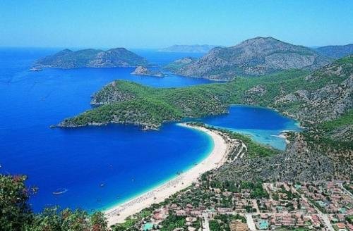
It is surrounded by Marmaris, Reşadiye Peninsula and Kerme Bay in the west, Ula in the north, Balan Mountain in the east, Montenegro and Everyday Tropes and the Mediterranean in the south. In front of the bay is Adaköy, which is bound to a fine dyer on the shore, in front of it is Bedir Island, Goat Island and Pigeon Island. The oldest part of the city is the Kale Mahallesi, which is built on a hill extending towards the sea. Marmaris later developed towards the skirts and towards the coast. Dalaman Airport, where air transportation is made, is only one hour away. Rhodes is only 45 minutes away.
The Mediterranean climate is dominated by the marshes in the summers are hot and dry, while the winter months are relatively warm and rainy. As to the orographic location of the mountains, Marmaris is Turkey's most abundant rainfall area after Rize and the annual rainfall is over 1200 mm. In winter, floods and torrents can be seen from time to time due to heavy rains. During the transition of the façade systems in winter, a lot of oraj (lightning-thunderstorm) is seen. The period from May to September does not show much precipitation and is quite dry. Due to the temperate effect of the sea, it rarely freezes in the winter months. Snowfall, though visible on high mountain slopes, rarely falls off coastal areas.
The history of Marmaris goes up to 12000 BC. The material found at the end of the excavations in Nimara Cave in Badir Island in 2007 confirms this. 17 September 2007 press conference in Marmaris Museum) ... Karia name of region Kar is the name of the country was later given to the meaning of the fertility of the Mediterranean and Aegean, The region has always been attractive. The city is the most important bridge to the Rhodes and Aegean islands. Thus, Marmaris has become a place where many civilizations have dominated over time.
It is possible to see the traces of the civilizations of Karia, Rhodes and the island, Egypt, Assyrian, Ionian, Persian, Macedonian, Syrian, Roman, Byzantine, Seljuk and Ottoman civilizations.
Fiskos is the first name of the city. Today, the remains of the so-called Asartepe can be seen.
3500 BC The first city walls of Fiskos, the Kariya city, are being built. Fiskos remains can be seen in Asartepe on the northeastern slopes of Marmaris Beldibi. The ancient city of Loryma in the 7th century BC (today in the Sömbeki gulf, Bozukkale, Taşlıca region) is being established.
Persian rule begins in 546 BC.
BC 334 The Greater Alexander occupies the region.
323 BC Alexander is dead. As the province of Karya enters the hegemony of the kingdom of Pergamum, Fiskos becomes the most important port city in southwest Anatolia of the Egyptian / Rhodesian empire.
226 BC There is a violent earthquake.
Rome domination in 133 BC begins.
395 The beginning of the Byzantine period
670 Arab raids. Most cities were burned and destroyed as a result of these raids.
Turkmen trench and Anatolian Seljuk State Period. In this period, the first settlement units in Tepe Mahallesi were established with the name of Mermeris.
1286 Period of the Menteşe Principality. In the 1300s, Marmaris is an important port, both in commercial and military terms, as it is in Fiskos in antique cities.
In 1300 the island of Rhodes plays an important role in the conquest by the Menteşe Emirate as the naval base. It is an important loading port of marble and timber trade in the Eastern Mediterranean.
1391 July 1391 Ahmed Gazi's death after the Ottoman Empire begins in the region.
1402 After the Battle of Ankara. By the order of Timurlenk, the reign of Menteşe Beylik begins again.
1451 Ottoman domination begins again in the region.
1480 Fatih Sultan Mehmet and 100.000 soldiers come to Mermeris to conquer Rhodes. The strong Ottoman Fleet of 150 ships, 89 days of conquest of the conquest is wasted.
1517 Mermeris has a population of 24 people. ???
1520-1522 Ottoman Sultan Suleiman the Magnificent goes to the Rhodes expedition and comes to Mermeris with an army of 150.000 people and conquers Rhodes. It commands the construction of a bridge, a caravanserai, and a bridge that encompasses the current Zhiyajali.
1525 Mermeris is an "accident" connected to Mugla Sanjak.
1545 In the return of the Rhodes expedition, the construction of Hafez Sultan Caravanserai, completed by Sultan Süleyman, was completed.
1565 Mermeris starts exporting up to 100,000 kilograms annually of Storax Oriental, which is only present here in the world and makes great shakes in Europe.
1789 İbrahim Ağa Mosque was built.
1801 For the first time in history, a "fleet exercise" by a navy is being carried out in Mermeris for about three months by 200 British war ships.
The prisoners taken in the wars of Egypt and Syria between 1800-1850 are brought to Mermeris.
1890 Mining export from Mermeris begins. Importing countries are Germany, France and Italy. The annual volume exceeds 50,000 tons.
1913 - In the First World War, a German armored ship is taking refuge in the port of Marmaris.
1914 - The French navy keeps the castle of Marmaris to the ground and causes great destruction.
1919 - Based on the Treaty of Sevres, Italy and Greece agree on each other, and Italians occupy the region.
1922 - 22 July, Italian soldiers leave Marmaris and MarmarThe ancient cities in Marmaris are located within the borders of Marmaris county: Physkos (Beldibi, Asartepe), Amos (Hisaronu, Turunç), Bybassos (Hisaronu), Kastabos (Hisaronu), Syrna (Bayırköy), Larymna Bozburun), Thyssanos (Söğütköy), Phoenix (Taşlıca), Loryma (Bozukkale) Kasara (Serçe Harbor), Kedrai (Sedir Island), Euthena and Amnistos (Karacasöğüt). All cities including Physkos, small cities of Kariya. Fiskos is the first city in the region to be the center of the port city and other settlements. Fiskos is the "birthmark" in Karya language. The reason for this name is that it contains all the elements and beauty of nature. Traces of extending to 3400 BC are known. This important port city of Ancient Kareya region, remains are located in Asartepe north of Marmaris city center. However, the walls of the city walls could reach the acropolis on a daily basis. It is located on steep mountain peaks and slopes like all Karian settlements. Herodot is the hill between Beldibi and Camiavlu and the valleys and slopes. The father of the historian Herodotus in Bodrum and the famous geographer Amasya Strabo speak of Fiskos as the harbor of Ephesus and Mylasa opened to the East. Sovereignty has become the only important port in the Mediterranean, especially in the Eastern Mediterranean. The fact that the highway network that connects important ancient capitals such as Mylasa, Alabanda, Troy, Bergama, Ephesus and Miletus to Fiskos has existed for a long time emphasized the importance of port seas in extreme relations, particularly with the "origin of countries" Egypt. Prior to all kinds of trade (slave, marble, timber and wine) Egyptian relations begin as the military and civilizations later expands. The famous Kadesh battle took place at the harbor of Fiskos with the transfer vessels of the Carian mercenaries participating in the Hittites' saft. They joined the later wars at the Egyptian saft. Some of these mercenaries settled in Nile Delta by establishing their own city (4 units). As a matter of fact, the first karyaca inscriptions were found here. From Egypt to Southwest Anatolia and to Adalara, the art of making sculpture in the normal human race for the first time entered Fiskos. Fiskos' own money is another proof that it is an important center. Fiskosun is a precious metal coin, collector in England. It was found in 1828, when Borell was in possession. This money is quite large, thick and extraordinarily lenght, with a relief that animates the horns on the surface, and the "Phi Upsilon sigma $ Y 2" on one line with the letters 18 Kariya. Fiskos connected to the emerging Egyptian-Rhodian empire, has increased its importance as a commercial port in this period. And he was able to carry this position to the later Roman and Byzantine periods. British King VIII. It is also interesting that Henry mentioned a documentary about Fiskos in 1513. There is a bust of marble from the young Tiberius (Bust of Tiberius) who was later exhibited in the Museum of Boston in the Museum of Marmaris (formerly Physkos). Below is the introduction of English in the bustle museum and the road map to the museum. "Provenance / Ownership HisBoston 1971.393, history: Said to have been found at Marmaris (ancient Physkos) on the southern coast of Caria, by date unknown with KJ Hewett, Esq. Purchased by MFA from Robert E. Hecht, Jr., November 10, 1971 "Many statues dating from the 4th century before Milatton (purchased from an English estate); 1971: purchased by Robert E. Hecht, Jr. , Sculpture blocks and tablets, especially in the vicinity of Eyishstone. According to the archaeologist George Bean, it is not the explanations of the lack of city remains that have been left over from Fiskos, which has always been an important port city during various civilizations, they are not buried under the earth. On the contrary, it is the possibility that the city was partly shipped to ships and transported for use in other city projects. Because the hills and slopes where the city is founded are still in the middle and under the ground, it is the famous port and sea of Fiskos. Loryma (Bozukkale) was established at Bozuk Bay in the southwestern tip of Bozburun peninsula. Koya is the most impressive building that reaches daily from the remains scattered over a very large area, well preserved on Burunbasi. There were nine rectangular towers. Today the towering tower in the north can be seen. Bozukkale harbor Blue Cruise boats and yachts are an important stopping point. Cedrai Gökova Gulf is known for its ancient Kedrai city and the famous Cleopatra Beach. Kedrai was a city of Karia, then bound to Rhodes. Kedrai means "cedars" (cedar tree). Kedrai, one of the most important settlements of the Rhodope Conquest, was surrounded by walls. The tower and its walls can be watched on the shore. Agora, various structuresIn the eastern part of the island, the north side of the island and the theater are in very good condition. Hydas (Selimiye) was established in Selimiye Bay (Kamışlı Bay) in the north of Bozburun Peninsula. In the city there is a monument tombs, a square-shaped tomb. It is 3 km away from Hydas, there is a surveillance on the beach and a few tombs on this horoscope. Erine (Hisaronu) 2 km to the Hisarönü district when you turn towards Bozburun on the 20th km of Marmaris-Datça road. The ancient ruins can be reached by 3 km from here. There are remnants of Roman period in Erine. Castabus (Bargaining) This sacred place near the ancient ruins and Hisarlik Village can be reached with an hour climb from the Hisarönü plain. The temple is located on a platform. The Ionian structure dating back to the 4th century BC also carries Doric items. The platform can be seen temples based on. The eye-catching walls supporting the platform were able to sustain their existence as much as day-to-day. The rundown theater in the south is the only structure that can be identified with the temple in the region. The Thyssanos (Söğüt) Söğüt neighborhood, 1 km south-west, has a Thyssanos settlement remnant on a hill slightly behind the school. Phenix, Fenix, Feniks, Phoenician "Fineket = Taşlıca" The ruins of Phoenix, a Kariya city, are located 4 km outside Taşlıca, between the village and the ancient settlement, probably due to the ruins of the ancient settlement. On the way to the antique turn, the tombs are encountered on the road first. At the center of the Asar hill, there is a building in a quite good condition and then the main necropolis (tombs) of the city. The city's acropolis is in Asartepe. It is located on the slope of the hill where the remains of the Orhaniye neighborhood of Ybassos are located. The remains of the city walls can be seen in a scattered landscape in the forest. Euthenna (Altinsigrisi / Karacasöğüt) is a town of Rhodes. Remains reaching today The city's necropolis on the top of Altınsivrisi, some wall remains, rock tombs and cisterns will be encountered about 2 km south east of Karacasöğüt neighborhood. There is another ancient city near Amnistos Karacasuk. The ancient city of Amnistos is on a nose near the neighborhood's remains. The remains of city walls reached the old harbor wall by the sea. The name of Marmaris was founded by the Turkmen, who were the first settlers on the hill where the city is now, by the name of Marble-city in the Byzantine period. During the reign of Menteşeoğulları, the golden age, this maritime port that lives on the international marble trade, was named Mermeris. In 1522, the role of Fiskos in ancient times was taken over by natural disasters, plundering, and the destruction of the bastion. "The name Mermeris has been translated according to the interests of the people in Marmaras, Marrakesh (Latin), Marmaris The name Marmaris was extensively used in the Italian occupation after World War I and later became official with the Republican era. Herodotus and Herodotus and the famous geographer Amasya Strabo came from Fiskos in antiquity, Ephesus and Mylasa The hill where both of them live is either under the sea or an island.The Herodotus is impossible to mean Marmaris with the name Marmaris.According to the rivarage, it is said that Sultan of Suleiman the Magnificent, The residence of Sultan Süleyman the Magnificent and the kalenin architect The saying that Marmaris came from the name "Mim as" for stubbornness is also far from this convincing. Hafza Sultan Caravanserai was actually built in 1545 and the caravanserai was built considering the bigger and more comprehensive function than it is today. Apart from the bath that existed until recently, the second floor, which functions as a "Han", was destroyed at various times. Now the number of small rooms with a size of 7 is actually 8 positions. 8.si is reserved on the disproportionate side. There are still 2 rooms in the rooms facing the bosphorus and the sea, but they are in very good condition, but they are hidden. The others have disappeared for various reasons. The magnificent bridge is a magnificent bridge, which is made of white cut stone, completely covering the present Limestone, to join it to the peninsula of Mermeris, which is the escarpment to the Karaağaça, followed by the Pilgrim Bridge. One of the other tips on the back of Ilica is around the old mosque.
Milas Bodrum Airport Marmaris Transfer.